|
|
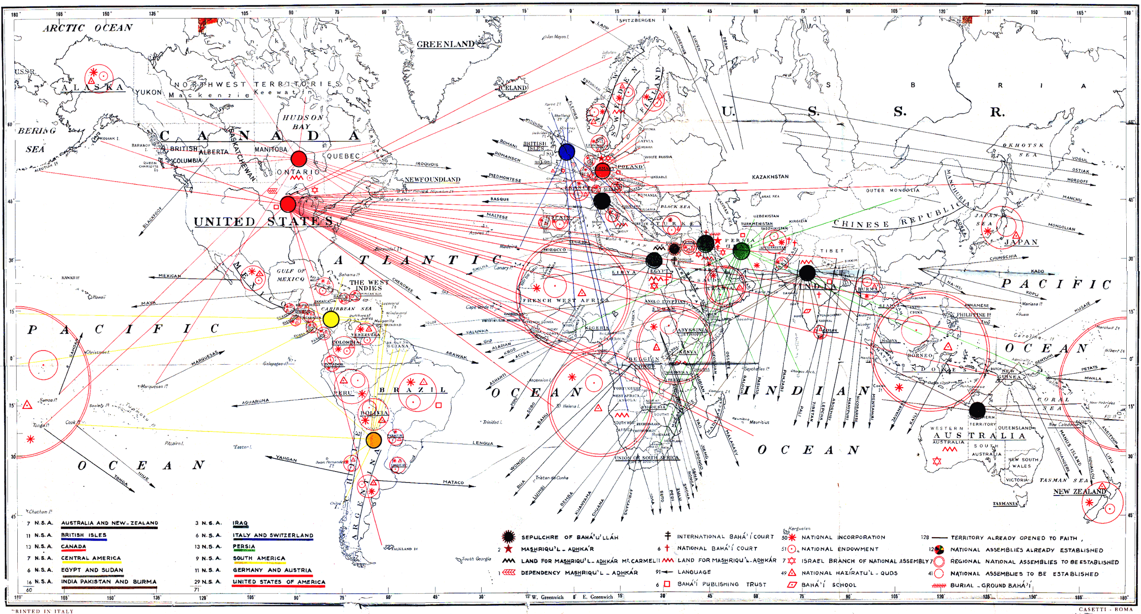
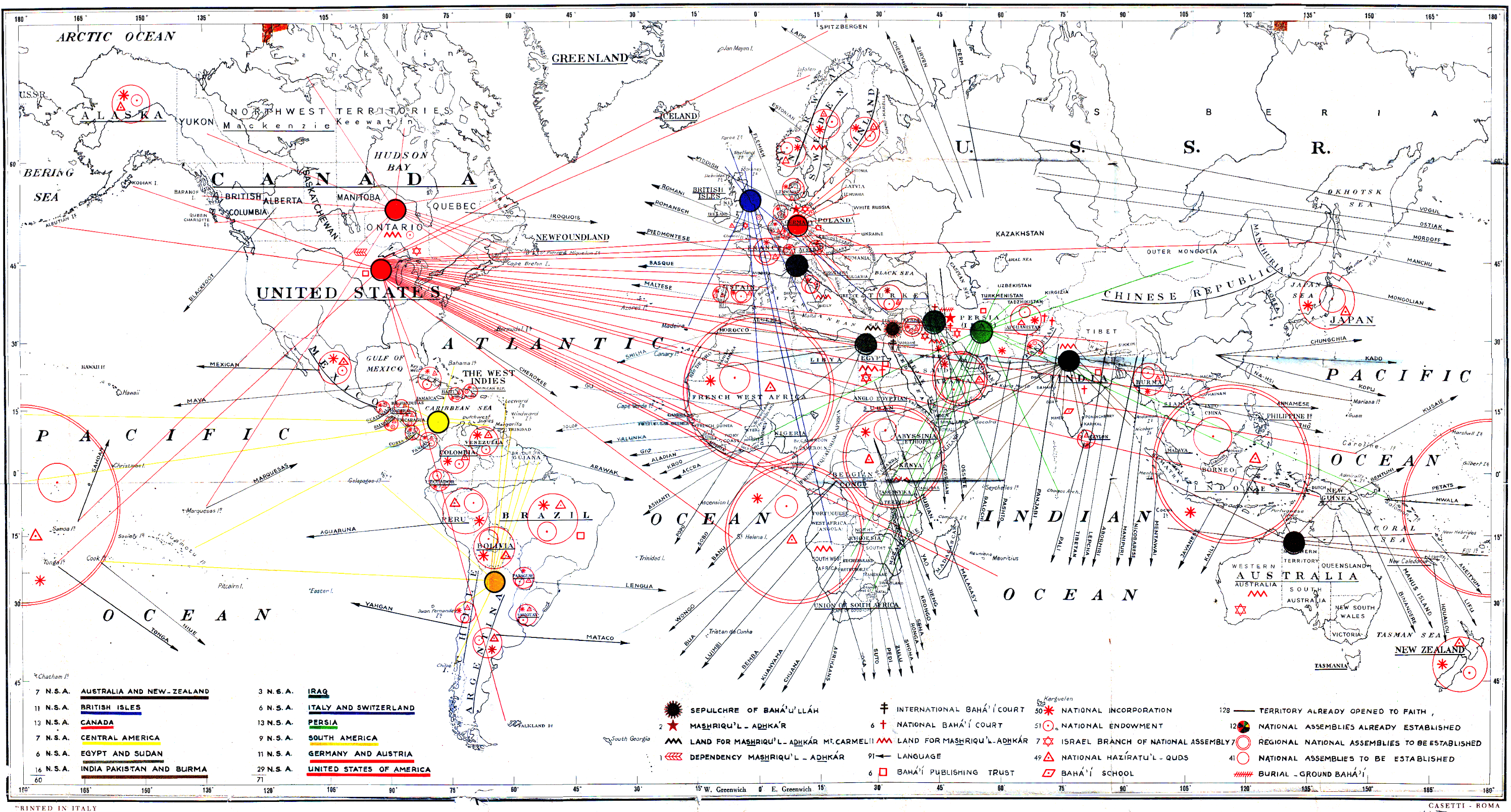
Abstract: Shoghi Effendi's map of progress goals for the Ten Year World Crusade, 1953-1963. Notes: Scanned for John Conkling, 2004. See also Index to Maps and charts in Bahá'í World volumes. |
Map of Goals for the Ten Year World Crusade
by Shoghi Effendi
published in Bahá'í World, Vol. 12 (April 1950-1954)Wilmette, IL: Bahá'í Publishing Trust, 1956
 medium image (2243x1207 px, 552K) |
 large image (2991x1609 px, 928K) |
Although there is no identification on this map as to its originator we know from references to it by the Hand of the Cause of God Ugo Giachery that it was prepared by Shoghi Effendi. He gave the original to Mr. Giachery to have printed in Italy. Mr. Giachery writes about the printing of this map and a second map published in 1958 in his book Shoghi Effendi - Recollections (George Ronald, publisher, pp. 43-46) as follows:
Twice it was my good fortune to handle the reproduction of two maps which Shoghi Effendi made to show to the Bahá’í world the goals and progress of the Ten Year Crusade: the ten year international Bahá’í teaching and consolidation plan, 1953-1963, and the victories won during the first five years of this plan, 1953-1958. The original maps entrusted to me for reproduction were drawn by Shoghi Effendi’s own hand. They represented the entire world, including the Arctic and Antarctic regions. By the ingenious and artistic use of well-conceived lines, colours, circles and other symbols, Shoghi Effendi presented on these maps (each on thirty-eight inches by twenty-two inches) the whole content of hundreds of pages of printing.[Ed Note: The "second map" is to be found on this website with the title “Progress Bahá’í World Crusade 1953-1958.” It was completed the day before Shoghi Effendi died in London, 1957. See bahai-library.com/progress_bahai_world_crusade]The first original was brought to me in Italy by a pilgrim returning from the Holy Land in the latter part of 1952. It had to be reproduced in time to be annexed to the booklet "The Bahá’í Faith 1844-1942: Information Statistical and Comparative," to be published simultaneously in London and in Wilmette [IL]. It was also intended for the Intercontinental Teaching Conferences held in Kampala, Chicago, Stockholm and New Delhi in 1953, and for the twelve National Bahá’í Conventions held in April of that same year. Knowing the reluctance of the Italians in general to print anything of which the Church of Rome may disapprove, I had to move wisely and cautiously to find a printer in Italy who would undertake to carry out the project without fear or eventual regret. After some unsuccessful attempts, when I was turned down for incredible reasons, I was able to locate a firm which agreed to execute the work. Map printing is an art in itself. It requires special machinery which at that time was not readily available in a country that was slowly recovering from the ravages of a disastrous war. . . .
As soon as the first copies of the first map came off the press, a sample was sent to Shoghi Effendi. It was swiftly acknowledged with a cable of thanks and praise. Instructions for a second printing were received in the spring of 1953, thus necessitating my presence in Italy and preventing my taking part in the Intercontinental Conference held in the United States.
The second map was prepared by Shoghi Effendi during the summer months of 1957.
Ugo Giachery, Shoghi Effendi - Recollections
Mr. Giachery makes a further reference to the map prepared by Shoghi Effendi showing the goals of the Ten Year Crusade when he writes that it was presented at the International Teaching Conference held in Kampala, Uganda, from February 12 to 18, 1953, the first of the four Bahá’í International Conferences called for by Shoghi Effendi that year.
“Along with these great messages, the Guardian sent a striking map of the world on which he had drawn the Crusade objectives, and, by means of colors and lines, charted the assignments and responsibilities given to teach country.” Further, he writes that the messages and maps were presented to the conference by Leroy Ioas, Hand of the Cause of God, who came as the Guardian’s representative to the Conference.Rúhíyyih Rabbání (the Hand of the Cause of God Amatu’l-Bahá Rúhíyyih Khánum) in her book The Priceless Pearl provided a description of Shoghi Effendi’s work on the map:The Bahá’í World, Volume XII, 1940-1954, p. 125.
. . . Shoghi Effendi set about devising the next stage of the Master’s Plan. It was beginning to take shape in his mind long before its detailed provisions were released through the publication in 1952 of his pamphlet The Bahá'í Faith 1844-1952, with its supplement "Ten Year International Teaching and Consolidation Plan", which was made public at the inception of the Holy Year (1953). Previously he had requested different National Assemblies to provide him with the names of territories and major islands of the five continents where Bahá’í activity was in progress, thus supplementing his own exhaustive list, which included the countries mentioned by `Abdu’l-Bahá Himself in the Tablets of the Divine Plan, and which he carefully compiled with the aid of atlases and works of references. I remember so vividly how he worked on his own map of the goals of the Ten Year Plan. He was tired out and run down after his long winter’s work in Haifa, with the Shrine, the gardens, the pilgrims, the interminable and ever-increasing correspondence. With difficulty I had extracted a quasi-promise that when he took a cure, at a well-known watering place, he would really rest and devote himself for that period at least to his health. The pleasant summer sun was shining outside, the long leafy alleys of trees, through which one went to drink from the various waters at specific times, were shady in the heat, it all beckoned to drowsy relaxation—but Shoghi Effendi spent the hours of daylight leaning over his map, filling in its details with infinite care. All my remonstrances and those of his doctor, my indignant reminder of his promise had no effect. He was wholly absorbed in his task, forgetful of tired muscles, strained eyes, overworked brain.More about the digital version of the map:The Priceless Pearl, p. 410, Rúhíyyih Rabbaní, Bahá’í Publishing Trust, London, 1969.
The paper copy came from the personal library of John W. and Eleanore D. Conkling. It was published as a pullout in The Bahá’í World, Volume XII (April 1950-1954), by the Bahá'í Publishing Trust, Wilmette, IL, 1956. The foregoing information from Hands of the Cause Ugo Giachery and Amatu’l-Bahá Rúhíyyih Khánum was collected by J. W. Conkling.
About preparation of the digital versions of the map: Jay Galvan produced the image by stitching together multiple scans and cleaning up old scotch tape marks and most fold marks. Jonah Winters optimized it for the web.
|
|